
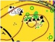
")
Calero County Park
Date: (Sun.) Sep. 30, 2018
Location: San Jose, CA
Event Director: ![]() - 408.599.9709
- 408.599.9709
Course Setters: Dan Greene, Quincy Rosenzweig, Eric Rosenzweig
Type: B; Standard seven-course event for beginners through advanced; National Ranking Event
Course Setters' Notes
By Dan Greene
This year the Calero courses have been designed in an "extended Middle-distance" format. That means they share the characteristics of both Middle courses and Classic courses. You'll find some rapid-fire short technical legs, like a Middle course, and some longer legs with route choices, like a Classic course. The winning times should be between those for Middle and Classic standards.
This event is a local event with "national ranking event" credits. At the event, this will be a typical local orienteering event. However, if you are a serious orienteer, you'll want to know that this event will contribute to your national ranking (https://www.orienteeringusa.org/rankings/). If you're interested in your ranking, we recommend that you register for your age-specific course color (http://www.orienteeringusa.org/rules#A39), so your run will contribute to your "proper" ranking. If you are not so serious, pick whatever course you'd like.
Here are the course specifications:
    Course    Length    Climb  Controls  Navigation     Terrain
    White     3.5 km    180 m     11     Beginner       Trails, Easy
    Yellow    3.2 km    160 m     13     Adv. Beginner  Mostly Trails, Easy
    Orange    3.1 km    260 m     12     Intermediate   Off-Trail, Difficult
    Brown     2.4 km    195 m      9     Advanced       Off-Trail, Difficult
    Green     3.1 km    260 m     12     Advanced       Off-Trail, Difficult
    Red       4.7 km    365 m     16     Advanced       Off-Trail, Difficult
    Blue      5.2 km    410 m     19     Advanced       Off-Trail, Difficult
Course Choice
White vs. Yellow
White is the easier course. It is on dirt roads and trails, a typical hike.
Yellow is actually slightly longer and more physically demanding than White, and appears to be shorter in the stats only because the course statistics above are reported as direct-line distances. The Yellow course predominantly follows trails, but gets slightly off-trail to make finding the controls more challenging, and it has optional, short, cut-across routes that may also lead to some off-trail travel.
Yellow and White follow the same basic loop, and therefore doing one of these courses after the other one will not give a significantly new challenge because of familiarity with the terrain.
Orange
The terrain for Orange is slightly more difficult than a typical Bay Area Orange course, so moving up from Yellow may not be a good choice at this event. Cleats are recommended on this course.
Comments About the Map
Start

The Start is shown on the map as per the 2017 IOF standard (2.5MB PDF) (https://orienteering.org/wp-content/uploads/2017/04/ISOM2017_20May2017.pdf), which shows the map pick-up and start of timing at the T symbol, and a dashed line to the start triangle. After starting, you must go to the start triangle (in this case 100 meters) before proceeding to your first control. This ensures that your route choice will not be visible to orienteers waiting at the Start.
There is no punch at the start triangle, but you will see a streamered triangle on the ground. There is no significant navigation advantage to skip visiting the start triangle (so please follow the rule requiring that you go to the triangle).
Contours & Map Scales
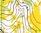
The contour interval is 7.5 meters, larger than usual Bay Area maps (usually 5 meters). This means that vertical considerations play a heavier role in route choice than usual.
All the maps will be printed at the standard 1:10,000 scale, except for Brown, which will be 1:7500.
Rock Features Vary in Mapping Threshold
In some places, the mapper has mapped boulders as small as 0.6 meters in height if they are isolated. However, in most of the map, especially areas of dense rock features, the standard 1.0-meter height threshold is used.
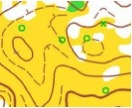
Please note the standard mapping conventions for boulder clusters. A black triangle indicates boulders that are too close together to be individually mapped. This can be confusing, because the largest boulders in an area might be absorbed into triangles due to their proximity with other boulders, while smaller, less prominent boulders are individually mapped. When boulders are smaller than the mapping standard, small black “rocky ground†dots are used—these dots do not indicate individual rocks, but rather an area of rocky ground. The map segment at the right shows clusters (black triangles), individual boulders (large and small individual black circles), and rocky ground (groups of black dots).
The Lake is Low
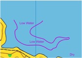
Because of seismic risk in the Calero dam, Calero Lake is being maintained at a much lower level than was originally mapped. In late season, this level is even lower than usual. In several areas, where it might affect route choice and/or navigation, we have sketched the current lower level with a purple line within the original (blue) lake. You will also find that the original lake level is frequently very visible as a shallow erosional cliff on the (now dry) hillside.
Down Trees are Inaccurate
The vegetation on the Calero map is significantly out-of-date. Many old down trees, mapped with green × or T symbols, have rotted and nearly disappeared, while many new down trees are not mapped at all. Thus, down trees should not be relied on for navigation. We have occasionally used them for control features if they are reliable, i.e., when they remain prominent and have other supporting features, such as nearby clearings.
We came across a number of prominent trees that had been split, with the fallen portion completely dead and the standing portion still alive. These are sometimes mapped as down trees, particularly if the roots are completely separated.
In the north part to the map, a rootstock is mapped with a brown ×. In the south part of the map, a rootstock or a standing dead tree is mapped with a green ×, or a green T if the direction of the trunk of a fallen tree is prominent. When the green T is used, the direction of the trunk, relative to the roots, is shown by the direction of the stem of the T, however, the length of the stem of the T is fixed and is not proportional to the actual length of the trunk. The map segment at the right shows dead- and down-tree features as shown on the southern portion of the map—many of these are decayed in the field.
Mapping of Lone Trees
A distinct, lone tree is mapped as a green circle. This mapping is based on the tree standing out when viewed in the terrain. It is not necessarily based on a tree's physical size—small trees can also be mapped as lone trees. When the trees are close together, the mapper has shifted to using the white-area symbol. Care must be taken when matching trees viewed in the field with the map: they may be individually mapped, or they may be part of a white area including several trees, as shown in the map segment at the right.
Open Areas with Thistle
Many of the open fields have been invaded with thistle. The vegetation varies with season, and these open areas are still shown as yellow, even though the new thistle might warrant mapping as rough-open or open-with-undergrowth. We have designed the courses not to depend on the mapping of thistle—nevertheless, for speed you may want to navigate around the blocks of thistle. In the field, from a distance, thistle will appear brown/grey, in contrast to the grasses, which appear yellow/tan. The grasses are much more passable.
Dotted-Black-Line Vegetation Boundary
At one location on the map, near a Red/Blue control, a long, dotted black line within a white area indicates a change from one type of forest to another, and should not be confused with a small erosion gully or dry ditch, which would be a dotted brown line.
Warnings
Cleats or Spikes Recommended
Due to the steep hillsides with loose soil and leaf litter, we recommend shoes with cleats (e.g., O-shoes or soccer shoes) for the intermediate and advanced courses (i.e., Orange, Brown, Green, Red, Blue).
Poison Oak
There is considerable poison oak in the park, although this late in the season it is very dry and less likely to cause an allergic reaction. If you are sensitive, you should take precautions and plan to wash afterwards with something like Tecnu. If you are new to poison oak, ask a regular for help identifying it. (Also, the bushes west of the start triangle are poison oak.)
Horses
You must give horseback riders right of way, and not charge out of the woods onto a trail near a horse. If you approach a rider while running on a trail, slow to a walk, and ask the rider for instructions on which side to pass.
Wildlife
If you do see wildlife, it will most likely be deer, geese, turkeys, or coyotes. Mountain lions are shy and seldom encountered. If you do encounter a mountain lion, do not run away—stop, hold any children in your group, and make yourself appear as large as possible. Rattle snakes are present in the park, typically in open areas or near rock features where they can enjoy the sun. They will usually provide warning and can be avoided. If you do get bitten, stop exercising and let other orienteers help you (i.e., use your whistle to call for help).
Ticks
Ticks are present in Calero, although the park is not heavily infested. Use insect repellant and/or inspect yourself afterwards. Remove ticks promptly, and seek medical attention if you notice signs of infection.