
Back to Schedule
Spooner Lake (May 24, 2003), Burton Creek (May 25-26, 2003)
Event Director's Notes
Burton Creek and Spooner Lake Course Setter's Notes
Entry list
Maps: Spooner Lake Venue, Lake Tahoe Region, Burton Creek Venue, Burton Creek Area
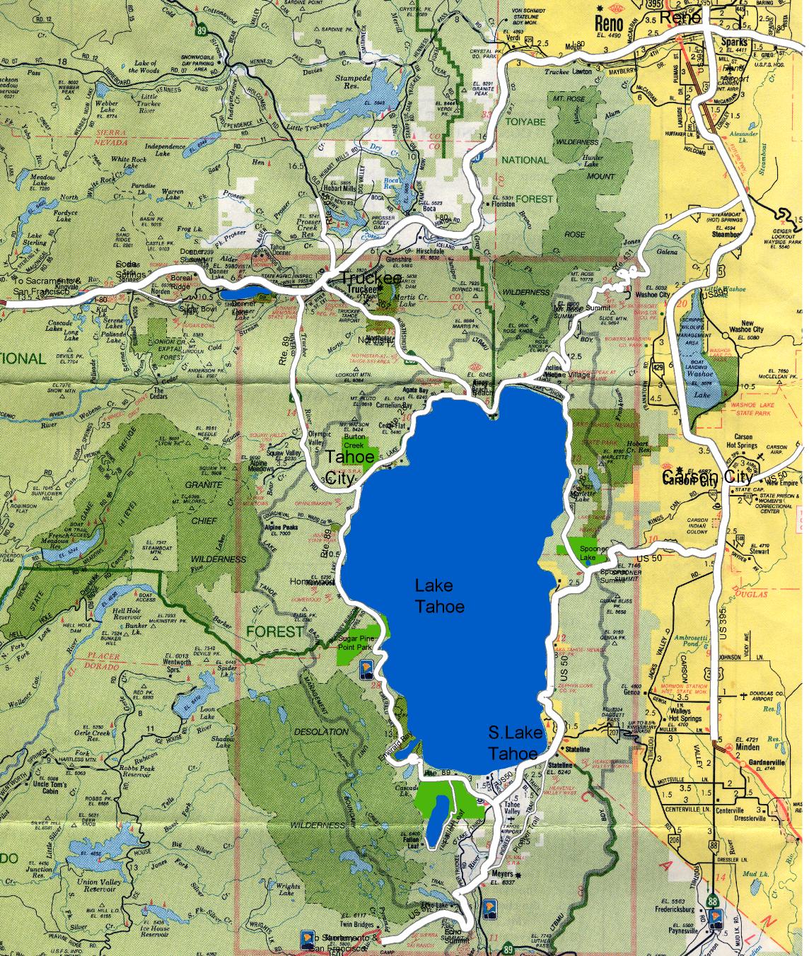
The Bay Area Orienteering Club will hold an early summer 3 day orienteering "A" meet at Lake Tahoe on Memorial Day weekend. On Saturday, the event will be across the highway from Lake Tahoe-Nevada State Park at Spooner Lake on the eastern shore of Lake Tahoe, and on Sunday and Monday at Burton Creek State Park near Tahoe City, California, on the north shore of Lake Tahoe. The nearest major airport is in Reno, Nevada, about 1 hour east of the event sites.
There will be a two day cumulative time classic distance event on Saturday and Sunday, with the first day at Spooner Lake and the second day at Burton Creek, and then a 1 day short course event at Burton Creek on Monday. This will be a "bare bones" A meet, meaning that there will be no dinner, no T-shirt, no model event, child care will be performed on a cooperative basis by the parents, and modest awards. However, there still will be interesting and challenging courses on good maps in good terrain with excellent event organization.
PDF of event flyer available for beginners
and advanced orienteers.
Terrain
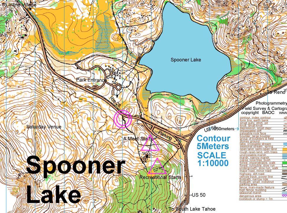
On Saturday, the US Forest Service portion of the Spooner Lake map west of highway 28 will be utilized. This area has not been used since August 2000. The central portion of the map is a moderately hilly with runnable pine forest, but drops off steeply to the west. There is complex rock detail in the northern part of the map. The trail network is relatively sparse except at the southern end of the map.
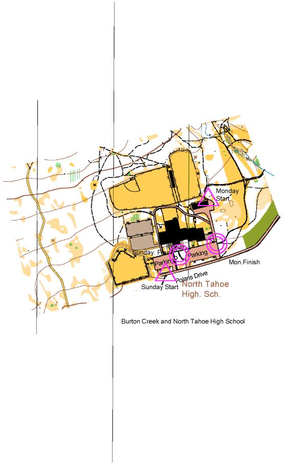
On Sunday and Monday, the events will be at Burton Creek State Park. Burton Creek offers some of the most interesting orienteering terrain in northern California. Terrain in California is notoriously known as being very steep, but Burton Creek is significantly flatter, with only mild to moderate climb, particularly in the northeastern portion of the park which will be utilized for the short course event. Large areas of the park are very runnable. The park is used as a cross-country ski area in the winter. Vegetation varies from meadow-like clearings covered with wildflowers, to pine forest, to brush and chaparral. There is no poison oak in the Lake Tahoe Basin. The density of rock features varies from sparse to moderate. Some parts of the terrain have many boulders which vary in size from 0.5 m to 5.0 m, with 1.0-2.0 m being the most common. The trail system ranges from moderate to relatively dense in the northeastern part of the park. Because of the unseasonably wet spring, many of the normally dry streams will be active. Also, there may well be some residual snow left on the ground. The altitude ranges from about 6800 to 7100 feet.
Climate
The climate in late May is usually sunny, with a high temperature between 60 and 70 degrees F. The humidity will be relatively low. Depending on the previous winter, there still may be snow on the ground.
Maps
George Kirkov mapped Spooner Lake in 1998, with revisions in 1999. The scale is 1:10000 with a contour interval of 5 meters. The Forest Service has done some clearing of trees in an effort to decrease fire hazard, and so the vegetation boundaries may have changed slightly since the map was made. This map also contains many small rough open clearings which may be hard to discern in the field. Since the same mapper produced both Spooner Lake and Burton Creek, one will get a good idea of his mapping style at Spooner.
The map scale for Burton Creek is 1:10000 with 5 meter contours. The map is generally quite good. George Kirkov did the original field checking and cartography in 1999 and 2000 and Zoran Krivokapic did extensive modifications in 2002. The contours are very reliable. Most of the rock features are well mapped. One source of confusion may be the "boulder fields". When the boulders became too numerous to be mapped individually, the small black scalene triangle, the boulder field symbol, is utilized. This symbol appears to be less prominent than the individual boulder (round black dot) and boulder cluster (relatively large black equilateral triangle) symbols. However, when the boulder field symbol is used it means that there are a lot of boulders in the area, and each boulder is not mapped individually. Only the very large boulders or significant boulder clusters are mapped in an area where the boulder field symbol is utilized.
The large clearings are quite reliable. However, there are numerous small clearings which may be difficult to discern, and you should not be rely on them for navigation. Many of these have been eliminated in the last field check and replaced with rough open with scattered trees. Similarly, individual trees (green X's), small copses (green O's), the brown X, which represents either a rootstock, a large stump or standing dead tree, and a brown T or a brown X with a line extending from it representing a downed tree (the long line is in the direction of the trunk) are sometimes difficult to discern in the field. Also, there are many stumps and downed trees that are not mapped. Therefore, these symbols may not be the most reliable feature to use for navigation.
There are new unmapped logging tracks here and there. The park is implementing a road to trail network and eliminating some roads and trails, but new ones created by mountain bikers appear frequently. We will make map corrections for the ones you are likely to encounter, but don't be surprised if you see a short but obvious unmapped track to a clearing just off a main logging road.
Hazards
The biggest hazard at this event is probably the altitude. You will be competing at 6200 to 7000 feet. One of the best ways to decrease some of the effects of high altitude is to stay hydrated throughout the competition. Start drinking water about 1 hour before your start, and drink water at all of the water stops. If it is warm, it is even more important to stay hydrated. There are no rattlesnakes or poison oak.. Bears are occasionally seen but they usually are not aggressive. Be alert for mountain bike riders on the trails. The safety bearing is east at Spooner Lake to Highway 28 and at Burton Creek south until you reach a residential area or Highway 28.
Whistles
Whistles must be carried by all competitors. If you do not have a whistle, ask for one at registration at no charge.
Classes
- There will be the standard 7 courses and 43 USOF classes for the A meet. Recreational white and yellow courses will be offered on both days.
- USOF COURSES: Standard courses are color coded for easy reference, as listed below.
- USOF CLASSES: F = female, M = male, Gr = group. The number denotes age on Dec. 31 of the year of the event. A dash or plus indicates no age limit on that side. For example, M-12 is open to boys 12 and under, F35+ is open to women 35 and older. "Open" and "21" classes have no age limit.
- CLASS/COURSE ASSIGNMENTS: This table shows which classes are assigned to each course at USOF-sanctioned events.
| COURSES: | WHITE | YELLOW | ORANGE | BROWN | GREEN | RED | BLUE |
| Difficulty level: | Beginner | Adv.begin. | Intermed. | Advanced | Advanced | Advanced | Advanced |
| Length (km): | 2-3 | 3-5 | 4.5-7 | 3-5 | 4.5-7 | 6-10 | 8-14 |
| CLASSES: |
F-10 F-12 M-10 M-12 MF-White Gr-White |
F-14 F-Yellow M-14 M-yellow Gr-Yellow |
F-16 F-Orange M-16 M-Orange Gr-Orange |
F-18 F50+ F55+ F60+ F65+ F70+ F-Brown M65+ M70+ M-Brown |
F-20 F35+ F40+ F45+ F-Green M-18 M50+ M55+ M60+ M-Green |
F21+ M-20 M35+ M40+ M45+ M-Red |
M21+ |
The following courses are for any age:
M-Brown M-Green
MF-White, Gr-White, F-Yellow, M-Yellow, Gr-Yel,
F-Orange, M-Orange, Gr-Orange, F-Brown, M-Brown,
F-Green, M-Green, M-Red
Winning Times
On Saturday and Sunday, there will be classic distance events with the following estimated winning times: White, 25-30 min; Yellow, 35-40 min; Orange, 50-55 min; Brown, 45-50 min; Green, 50-55 min; Red, 60-65 min; Blue, 75-80 min.
For Monday, the short course winning times will be 25 minutes for the blue, red and green courses, and 20 minutes for brown course. Orange, yellow, and white will be "classic distance" and the winning times will be those listed in the previous paragraph.
Training
No formal training course will be set up, but training maps of Boreal and Northstar will be available for sale and use before the event. Maps of Spooner Lake and Burton Creek may also be purchased. All maps are $3.00, and can be ordered on the entry form.
Electronic Punching
SportIdent electronic punching will be used for all classes on all three days of the A meet. If you do not own your own SI Card, you may rent one for $2.00/day. Please indicate on your entry form the number of your SI Card, or whether you need to rent one. White and yellow recreational courses will use standard paper punch cards.
Entry Fees
Postmarked by April 26, 2003:
- Adult $20.00/day
- Junior $10.00/day
Postmarked between April 27 and May 10, 2003:
- Adult $25.00/day
- Junior $15.00/day
Day of event entry:
- Adult $30.00/day
- Junior $20.00/day
Adult members of USOF or another national federation belonging to the IOF receive a $3.00/day discount of the above fees. Juniors (18 and younger) who are members of USOF receive a $1.50/day discount.
Other Fees
- SI Card rental: $2.00/day
- Loss of rental SI card $30.00
- Compass rental: $1.00/day
- Training maps of Burton Creek, Northstar, Boreal, or Spooner Lake $3.00 each
No pre-registered entries will be accepted after May 10th. Entries received with a postmark later than May 10th will be treated as a day of event entry. Day of event entries will be accepted for the A Meet, but these entrants will not receive assigned start times and will have to wait for a vacancy in the start list for their start time.
Complete a standard USOF entry form (editor: bad link to "http://www.us.orienteering.org/Forms/standard2002.pdf" removed), enclose a check made payable to BAOC, and send them to the registrar at the following address:
Steve Beuerman
963F La Mesa Terrace
Sunnyvale, CA 94086
1-408-739-9376
beuerman![]() ix.netcom.com
ix.netcom.com
You may also register online.
Foreign participants
Information about obtaining a visa for entry into the US can be found at http://travel.state.gov/visa_services.html. Foreign competitors may pay at registration when they pick up their packets.
Awards
Separate awards will be given to the top 3 finishers in all classes for the combined time 2 day classic distance event and also for the short event. The awards ceremony will begin as close to 2:00 pm on Sunday, May 25th, and 12:00 p.m. on Monday, May 26th as possible.
Recreational and Big Blue Adventure Racing Training Event Courses
White, yellow, and orange recreational courses will be available. In addition, a special orienteering training course for adventure racers will be provided. This training course is provided with cooperation
of the
Big Blue Adventure Race series. This will be of intermediate navigational difficulty, but relatively long (equivalent to a long orange course) on Sunday, May 25th. No pre-registration is required. For the white and yellow courses, the entry fees are $6.00 per individual or first member in a group and $2.00 for each additional person in a group. Juniors are half price. The orange courses and AR training course is $8.00 for members and $12.00 for non-members. Electronic punching will not be used. Different courses will be offered on Saturday and Sunday. There will not be any recreational courses on Monday. Registration opens at 9:00 a.m., beginner's clinics are between 9:30 and 10:30 a.m., and start times will be available from 10:00 a.m. to 12:00 noon.
Childcare
Childcare will be provided as a parent cooperative effort. We will provide a childcare coordinator. No formal paid childcare will be available.
Dinner and T-shirt
This will be a "bare bones" event, with no formal Saturday night dinner or T shirt.
Olivia Graeve is organizing a get together for dinner on Saturday, May 24th at the Blue Agave - a great mexican restaurant in Tahoe City (425 N. Lake Blvd., Tahoe City, CA).
It should be a fun evening with orienteering friends. The restaurant has reserved a table for us and they have agreed that we will have separate checks for different groups of people. Everyone will pay for their own meal, drinks, etc... There will be no course reviews, but do brings your maps so that you can discuss your courses with other sympathetic ears around the table.
As informal as it sounds, since the restaurant is going through the trouble of preparing so many different checks, the maitre de wants to know how many people will be showing up, so that she can organize the waiters appropriately.
If you are interested, please RSVP to
Olivia by May 14.
Important Dates and Program
April 26 - Last day for entry without late fees
May 10 - Last day for entry with pre-assigned starts in A meet
May 23 - 6:00-10:00 p.m. - Packet pickup available at the Tamarack Lodge, 2311 North Lake Boulevard, Tahoe City, 1.6 miles east from the Tahoe City "Wye" on Highway 28.
May 24 - Day 1 or classic distance event at Spooner Lake. Registration opens 9:00 a.m. First starts at 10:00 a.m.
May 25 - Day 2 of classic distance event at Burton Creek. Registration opens at 8:00 a.m., first starts at 9:00 a.m.
Awards Ceremony for classic distance event at 2:00 p.m.
May 26 - Short Course event at Burton Creek. First starts at 9:00 a.m. Awards ceremony at 12:00 noon.
Accommodations
There are a large number of accommodations at Lake Tahoe ranging from campgrounds to resorts. The motels between Tahoe City and Incline Village are the most convenient. The less expensive motels can generally be found in King's Beach, about a 15-20 minute drive from the event sites. The motels on the Lake side of the highway tend to be much more expensive than those on the other side of the road. Memorial Day weekend is the beginning of the high season for Lake Tahoe, so if you care about the place you stay in, you probably should make early reservations. Tamarack Lodge in Tahoe city will serve as the headquarters motel. Directions are below.
On Saturday, parking will be at the Nevada Highway Department lot just north of the intersection of US 50 and Route 28. On Sunday and Monday, there is free parking in the North Tahoe High School parking lot. In addition, you may park on the streets near the school.
Directions
To Spooner Lake:
From the Bay Area: take I-80 east to Truckee. In Truckee, take Route 267 south towards Kings Beach. At the T-intersection, turn left onto route 28 east. Go for another 18 miles until you see O signs. Turn left into the park and pay a $5.00 parking fee. Alternative route from the Bay Area: Take I-80 east towards Sacramento, then US 50 east towards South Lake Tahoe. Continue on US 50 through South Lake Tahoe, and about 14 miles later, turn left onto Route 28 North. Go about 0.5 miles, and turn right into the park.
From Reno: take U.S. 50 west through Carson City and up Spooner Summit. After crossing the summit, turn right onto Route 28 north towards Incline Village. Follow O signs to parking.
To Burton Creek:
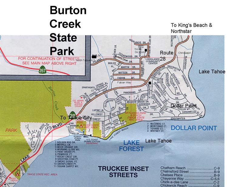
From the Bay Area: from I-80, turn south on Route 89 towards Tahoe City. In Tahoe City, at the Y-intersection, continue straight on Route 28, North Lake Boulevard. Go about 2 miles towards Dollar Point, turn left onto Fabian Way (there is a 7-11 on the south side of the highway), then an immediate right onto Village Road. Turn left at the 3rd intersection onto Polaris Drive, and go to the end of the street and follow signs for parking at the North Tahoe High School.
From Reno: take I-80 west to Truckee. Go south on Route 267 until you come to the T intersection with Route 28 in King's Beach. Turn right and go west until you come to Dollar Point, then turn right onto Fabian Way and then an immediate right onto Village Road. Turn left at the 3rd intersection onto Polaris Drive, and go to the end of the street and follow signs for parking at the North Tahoe High School.
To Tamarack Lodge, Headquarters Motel:
Go east from the Tahoe City "Y" on Route 28 for about 1.6 miles. It is on the north (non-lake) side of the road.
Event Officials
Event Director, Evan Custer, 1-925-254-5628, evancuster![]() attbi.com
attbi.com
Course Setter, Saturday classic distance courses at Spooner Lake, Thorsten Graeve
Course Setter, Sunday classic distance courses and Monday short courses at Burton Creek, Dan Stoll-Hadayia.
Vetter, Bob Cooley
Mapping Director, Bob Cooley
Registrar, Steve Beuerman, 963F La Mesa Terrace, Sunnyvale, CA 94086, 1-408-739-9376, beuerman![]() ix.netcom.com
ix.netcom.com